Landslide risk assessment and mitigation options analysis for the Whitehorse escarpment

GEO students

Aldo Behrens, Oliver Brubacher, Karan Perhar and Hunter Straughan

Our project

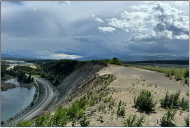
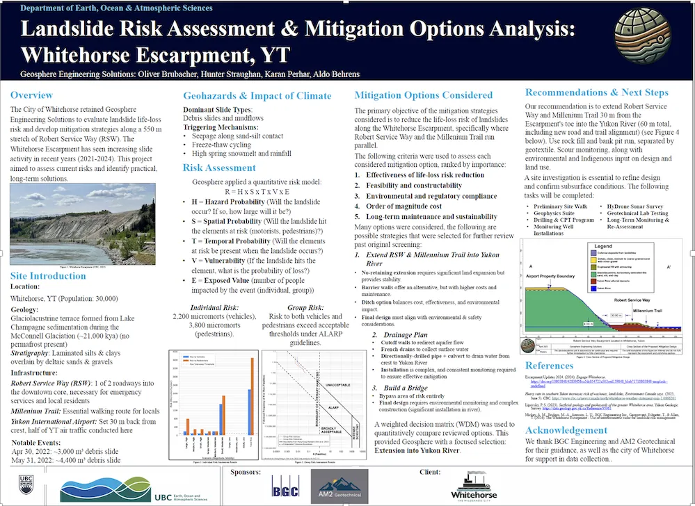
There have been an increasing number of landslides on the escarpment along a stretch of Robert Service Way in the City of Whitehorse. A large landslide in 2022 closed the road, and another a month later closed access for several weeks. Robert Service Way is one of only two roadways into the city’s downtown core, making it a critical transportation corridor, and the adjacent Millennium Trail is a popular walking route. 

We were asked to quantify the landslide life-loss risk for users of Robert Service Way and the Millennium Trail along a 550-metre stretch of the road and to propose recommendations to mitigate risk.  

Image
Geo

Our design solution and process

Landslide risk is heightened during the period from April to June, when melting snow creates a rising water table that seeps through the face of the slope, triggering erosion and resulting in debris slides and mud flows. 

We developed a quantitative risk model that incorporates local climate data, LiDAR data provided by our client, traffic data from the City of Whitehorse and other data sources. 

Our model evaluates landslide risk by looking at hazard probability, spatial probability, temporal probability, vulnerability and exposed value (the number of people at risk). Our analysis shows there is currently a very high individual risk to people, whether they are pedestrians walking along the Millennium Trail or in vehicles driving along the road. The life-loss risk significantly exceeds the level of risk deemed acceptable under current guidelines. 

Following the risk assessment, we conducted a mitigation options analysis. We researched extensively to identify appropriate options that could be used on this slope and performed a thorough review of the most promising 10. This review considered the magnitude of risk reduction, environmental impact, cost, and long-term maintenance and sustainability. 

We narrowed our list to four options and used a weighted decision matrix to quantitatively evaluate and compare them. This included conducting a series of sensitivity analyses to quantify the risk reduction of the various scenarios.

Based on our analyses, we have determined that extending Robert Service Way and the Millennium Trail into the Yukon River by 30 metres is the most cost-effective and feasible solution for reducing life-loss risk. This would also involve excavating a four-metre-deep catchment ditch between the escarpment’s toe and the new road alignment to intercept any potential debris. 

Image
geo_3

The challenges we faced

When we started this work in September, we had minimal knowledge of what was involved in a quantitative risk assessment – it was not until second semester that we covered this type of assessment in one of our courses. 

That meant that we had to teach ourselves how to do this kind of analysis. In fact, for the first two weeks, we were performing the wrong kind of assessment altogether.

Another challenge was collecting and integrating many different applicable data sources and aligning the data in ways that made sense. 

What we’re most proud of

Unlike other projects, this was an extremely open-ended capstone project that gave us the freedom to come up with any number of solutions. It’s been meaningful to work on a real-world engineering challenge and propose a solution that could potentially save lives. 

Additionally, it was satisfying to produce a comprehensive engineering technical report before we head out into the working world. It’s meant a lot to have gained this experience of being part of a team and knowing that we are more than capable of working on these kinds of challenges. 

Our project’s future

We’ve proposed a site investigation plan – which includes geophysical surveys, borehole drilling, CPT tests and groundwater monitoring – to collect the additional data needed to better understand the subsurface conditions and refine the design. 

Our recommendations will be submitted to the City of Whitehorse, who will then determine the course of action they want to take to mitigate risk along this section of the Robert Service Way and the Millennium Trail.

UBC geological engineering student on a co-op placement at BC Research Inc.

Geological Engineering

UBC offers the Geological Engineering program in collaboration with the Faculty of Science, blending aspects of earth sciences, civil engineering and mining engineering with a fundamental understanding of the earth’s surface environments...

Geological Engineering

Let's Work Together

Join us. Bring research and innovation insight to your biggest challenges. We work with industry, non-profit and government partners to accelerate solutions for the future.

Partner with Us

Discover Student Experiences

UBC Applied Science students are people who are passionate about their chosen field — architecture, landscape architecture, community and regional planning, engineering and nursing — and those that inspire others by making meaningful contributions to the betterment of society.

Browse Student and Alumni Spotlights
An engineering student at the Design and Innovation day exhibit

Want to know more about UBC Engineering?

Sign up to receive emails from us, and every few weeks we’ll keep you up to date on topics to help you learn more.

Subscribe now

UBC Crest The official logo of the University of British Columbia. Arrow An arrow indicating direction. Arrow in Circle An arrow indicating direction. Caret An arrowhead indicating direction. E-commerce Cart A shopping cart. Time A clock. Chats Two speech clouds. Facebook The logo for the Facebook social media service. Social Media The globe is the default icon for a social media platform. TikTok The logo for the TikTok social media platform. Calendar Location Home A house in silhouette. Information The letter 'i' in a circle. Instagram The logo for the Instagram social media service. Linkedin The logo for the LinkedIn social media service. WhatsApp The logo for the WhatsApp social media service. Location Pin A map location pin. Mail An envelope. Telephone An antique telephone. Play A media play button. Search A magnifying glass. Arrow indicating share action A directional arrow. Speech Bubble A speech bubble. Star An outline of a star. Twitter The logo for the Twitter social media service. Urgent Message An exclamation mark in a speech bubble. User A silhouette of a person. Vimeo The logo for the Vimeo video sharing service. Youtube The logo for the YouTube video sharing service. Future of work A logo for the Future of Work category. Inclusive leadership A logo for the Inclusive leadership category. Planetary health A logo for the Planetary health category. Solutions for people A logo for the Solutions for people category. Thriving cities A logo for the Thriving cities category. University for future A logo for the University for future category.